Egypt
And yet more. I am rather partial to satellite views. These are from The Gateway to Astronaut Photography of Earth website. The last lot, I promise! Click on the link beneath the image to go to the page where the full sized image is shown, together with details.
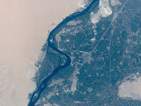 Kom Ombo
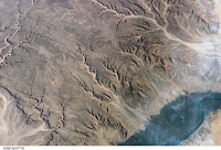 Eastern Desert Wadis
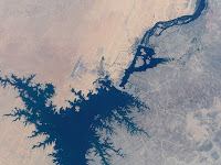 Aswan High Dam
- Daily Photo - Sahara Satellite Image
A gorgeous photograph of the Sahara desert. Click on the image to go to the Wikipedia version, where you can see the full sized image and zoom in on certain areas. The Nile is a great green snake to the east, and the Saharan highland zones stand out particularly...
- Daily Photo - Visible Earth
Staying with the theme of satellite imagery, today's photographs are taken from NASA's Visible Earth website. Each of the links under the photo takes you to a page of explanatory text about the image, and you can view the same image in different...
- Daily Photo: Eastern Desert Rock Art
As a nod to the rock art research mentioned above at Dakhleh Oasis in the Western Desert, here are some photographs of rock art in the Eastern Desert - a very different kettle of fish! For a start, except for one known image, all of the rock art in the...
- Daily Photo Archive
I was asked yesterday if my blog has an archive for the daily photos, which it doesn't. However, I have now added a hyperlink to the Links list so that when you click the Daily Photo link (third one down at the moment), you will find that all of the...
- Egyptian Remote Sensing Satellite Unveils Cairo Secrets
State Information Service Dr. Mohammad Argon, Director of the Egyptian Space Program said that a composite satellite photo was taken by the MisrSat-1 launched on April, 17, 2007. The photo presents the colors of the desert areas around Cairo, indicating...
Egypt
Daily Photo - Last set of satellite photos
And yet more. I am rather partial to satellite views. These are from The Gateway to Astronaut Photography of Earth website. The last lot, I promise! Click on the link beneath the image to go to the page where the full sized image is shown, together with details.
Kom OmboEastern Desert WadisAswan High DamGebel Uweinat
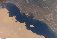
Lake Qarun, Faiyum
- Daily Photo - Sahara Satellite Image
A gorgeous photograph of the Sahara desert. Click on the image to go to the Wikipedia version, where you can see the full sized image and zoom in on certain areas. The Nile is a great green snake to the east, and the Saharan highland zones stand out particularly...
- Daily Photo - Visible Earth
Staying with the theme of satellite imagery, today's photographs are taken from NASA's Visible Earth website. Each of the links under the photo takes you to a page of explanatory text about the image, and you can view the same image in different...
- Daily Photo: Eastern Desert Rock Art
As a nod to the rock art research mentioned above at Dakhleh Oasis in the Western Desert, here are some photographs of rock art in the Eastern Desert - a very different kettle of fish! For a start, except for one known image, all of the rock art in the...
- Daily Photo Archive
I was asked yesterday if my blog has an archive for the daily photos, which it doesn't. However, I have now added a hyperlink to the Links list so that when you click the Daily Photo link (third one down at the moment), you will find that all of the...
- Egyptian Remote Sensing Satellite Unveils Cairo Secrets
State Information Service Dr. Mohammad Argon, Director of the Egyptian Space Program said that a composite satellite photo was taken by the MisrSat-1 launched on April, 17, 2007. The photo presents the colors of the desert areas around Cairo, indicating...